How Printed Star Charts Found Their Place
Printed star charts turn a crowded sky into a portable map, helping you orient yourself outdoors and use digital tools without surrendering your bearings.
The common mistake with printed star charts is holding the page as if it were a picture of the sky. That reverses the view, puts familiar stars in the wrong places, and can cost a clear stretch of observing time while you turn paper in circles. A chart works better as a portable aid to orientation: first you learn how its page represents the sky, then you use it to locate what is above you.
Start with the chart’s point of view
Printed star charts put a curved sky onto a flat page. The simplest charts show a broad region, often with constellations and bright stars spaced for quick recognition. More detailed atlases divide the sky into smaller map sheets, where fainter stars and less familiar objects have room to appear. Neither format is a complete view from every place at once. Each is a selected patch, drawn according to a particular projection and scale.
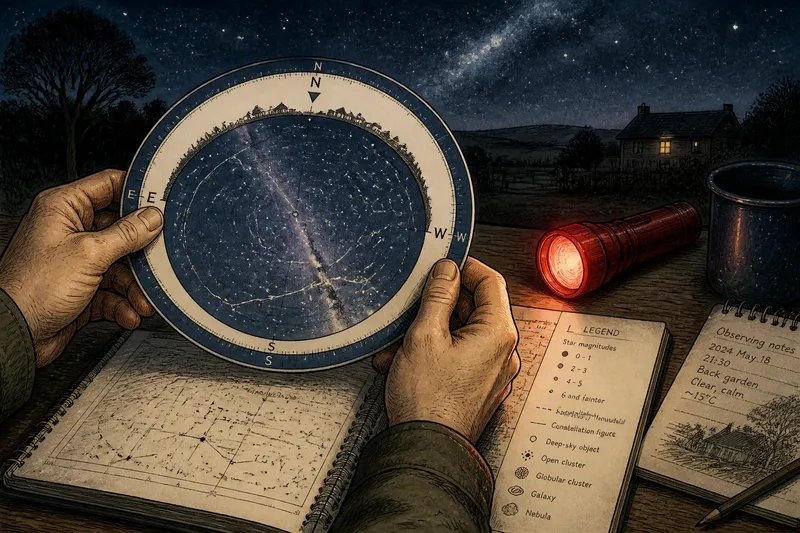
Check the chart’s legend before you head outside. It explains the symbols for stars, constellation boundaries, deep-sky objects, and other features. A star’s printed size often indicates brightness, while different line styles may mark constellation figures or borders. The legend is the map’s key, not decorative fine print; without it, a cluster of dots can look like an ambitious printing error.
Look, too, for the chart’s date or edition and the range of sky it covers. Some maps show the whole celestial sphere in a compact form; others offer more detail for a smaller area. A planisphere, with a rotating window, is designed to show which stars are above the horizon at a selected time and date. A star atlas is better suited to examining a specific region in greater detail.
Turn the page toward the sky
At the observing spot, begin with the horizon and a direction you can identify. North, south, east, and west are more useful than trying to match a page to “up,” since the sky’s apparent orientation changes as you face different directions. If the chart has a compass rose, use it to find the corresponding edge of the sky.
Hold the map so the direction you are facing is nearest your body. On many circular charts, the horizon is printed around the edge and the center represents the region overhead. The chart’s printed north may therefore be at the side rather than the top. Rotate the page until its directions match the ground around you, then compare the pattern of bright stars with the pattern overhead.
Use a recognizable anchor before searching for a faint or unfamiliar point. A prominent star, a distinctive line of stars, or the boundary of a familiar constellation can establish where you are. Move from that anchor across the chart in small visual jumps. This is more dependable than scanning the page for a name and hoping the named object has made itself obvious.
Say you are standing in a backyard and can identify a bright star low in the east. You turn a planisphere to the current date and time, rotate its eastern edge toward the horizon, and match the nearby pattern. The expected observable result is a chart orientation that helps you distinguish the neighboring stars, rather than a page that merely happens to contain their names.
Choose paper for the task
A planisphere is handy when the question is broad: what part of the sky should be visible now? Its rotating mask filters the chart to a particular time and season, making it a useful first stop before detailed searching. It is less helpful for fine identification if its symbols crowd together or the target is not included.
A printed atlas or single-region chart is more suitable when you already know roughly where to look. Its larger scale can show dimmer stars that act as stepping stones from a bright anchor toward a target. The tradeoff is that you must choose the correct sheet and orient it yourself. A full-sky chart is easier to survey but compresses detail; a regional map is less sweeping but gives individual stars more space.
Paper also has ordinary practical virtues. It needs no charged battery or network connection, and a page can be consulted without switching between a bright screen and the sky. A dim red flashlight can preserve more night vision than a bright white beam, though even red light should be kept low enough that the chart remains readable without flooding nearby observers.
Use printed charts alongside newer tools
Phone sky maps can identify objects quickly by using the device’s orientation sensors and a live display. They are convenient for checking a name or getting an initial direction, but screen brightness, sensor drift, or an imprecise hand position can make the display distracting. A paper chart gives a stable, wider view of the surrounding pattern and makes it easier to see how one region relates to another.
The two tools need not compete. Use a phone to confirm a candidate, then lower the screen and return to the printed map to understand the star pattern around it. Or begin on paper, locate a bright anchor, and use an app only when the map’s symbols or scale leave a question unresolved. The chart acts like a paper road map beside a car’s navigation display: one gives the broader layout, while the other can answer an immediate location question.
Printed charts have not simply survived as nostalgic objects. Their role has shifted from being the only practical map many observers carried to providing a quiet, durable reference alongside digital aids. That makes their limits worth understanding: a chart cannot automatically adjust to the observer’s location, the local horizon, or changing conditions. It shows a designed representation, and the observer supplies the comparison with the actual sky.
Which printed star chart should you use?
Is a planisphere enough for learning the sky?
It can help you learn which constellations and bright stars are likely to be visible at a chosen date and time. For dimmer stars or a close search around a particular object, a more detailed regional chart is usually easier to read.
How do I tell whether a star chart is upside down?
Match its compass directions to the direction you are facing, then check whether a bright anchor star appears in the same part of the sky as on the page. If the surrounding pattern does not line up, rotate the chart rather than assuming the sky is at fault.
Can I use an old printed star chart?
Most stars used for basic orientation remain in familiar patterns over ordinary observing timescales, so an older chart can still be useful for that purpose. Check its legend and coverage, and use a current source if you need time-sensitive information such as a planet’s position.
Should I choose paper or a phone app?
Choose paper when you want a broad, stable view without a glowing screen; choose an app when you need a quick identification or an adjustable display. Keeping both available lets you use printed star charts for orientation and digital tools for questions the page cannot answer.
Leave the map ready for the next clear night
After observing, note the chart or atlas sheet you used and mark a few anchors you recognized. A simple pencil mark beside a constellation or a short note in a notebook can make the next session easier to begin. Keep the chart folded or stored so its legend and useful region are easy to reach; a map buried beneath unrelated pages has a fine record of being owned.
The lasting value of printed star charts is not that they outperform every newer tool. It is that they teach the eye to relate one visible pattern to another, with the whole page available at a glance. Once you can orient the paper to the horizon, it becomes less an illustration to decode and more a steady reference you can carry outside.